If I could have a dime for every email I have received that asks some form of “will X-Plane 10 have X” (where X is a feature or enhancement), I wouldn’t need to actually work on X-Plane anymore. (If you think your email triggered this post, well, there are approximately 100 other users who have asked the same thing.)
Simply put: I have no idea and I’m not going to try to answer these questions any more. Here’s why:
For as long as I have been involved with X-Plane, Laminar Research has provided free patches to the simulator throughout a major version run, and those patches have included not only performance enhancements and bug fixes, but also major new features.
So the question “will X-Plane 10 have X” can really mean one of two things:
- Will X-Plane 10.0 have feature X immediately ‘on the DVD’?
- Will X-Plane 10.x ever have feature X in a free patch before the major version run is over.
I can answer the first question, because we are relatively locked down on what features are still on the table for 10.0 vs. what must wait, but I think it’s at best confusing to do so. If a feature isn’t on the DVD, it might be in a free patch within weeks; it might be available by the time you get your DVD. Whether a feature is on the DVD is of interest to us as we plan our release, but I don’t think it actually makes a huge difference to users with internet connections.
Consider 64-bit – it’s something we want to look at during the version 10 run but we’re not going dig into it until after we get 10.0 out. So will 10.0 be 64-bit? No. But there will probably be a 64-bit patch available for free. I think you can see why I don’t want to post “X-Plane 10 will not be 64 bit.”
I cannot possibly answer the second question, because versions run over several years, and what we code for the end of the version run will depend on market conditions and technology that don’t exist now. One of the nice things about patching X-Plane frequently is that we can revise our plans as conditions change.
Consider the question “how many cores will X-Plane 8 utilize” had you asked the question during X-Plane 8.0. When X-Plane 8.0 came out, the answer was “only one” and we had no road-map to change that. For that matter, multi-core machines were rare and exotic beasts at the time, so multi-core wasn’t a priority.
Within the three years of X-Plane 8’s major version run, we ended up supporting multi-core for scenery mesh loading, something that couldn’t have been easily predicted at the beginning of the version run.
Finally, a note on release planning: now is absolutely not a good time to ask for features. The features that will ship in X-Plane 10.0 have already been determined, and since we’d like to ship X-Plane 10 sooner rather than later, I don’t think there’s anything you can say that would make us add a feature to 10.0.
All future features are going into a 10.x “bucket” for planning purposes. Since Austin, Chris and I are up to our eyeballs in code and the art team is red-lined too, we’re not spending any time sifting through 10.x buckets right now. If you send us a feature request, the very best case is that we dump it in a holding list for later; the worse case is that we lose track of the request in the chaos.
That doesn’t mean that we don’t care about 10.x. It’s just that we are very much heads down in the 10.0 release now and won’t look up until it’s done.
Just a quick note re: comments. Recently this blog has been attacked by spammers who copy existing legitimate comments and re-post then; their user name is a link to a click-harvesting web-site. I am doing my best to mark these comments as spam and not allow them.
Besides that, I am likely to nuke any comments that contain profanity, spam, repeated requests for tech support via the blog, and off-topic comments particularly on posts that have are meant for a narrow discussion (e.g. global scenery defects).
I have mentioned a few of the scenery engine features coming in X-Plane 10 that will be of interest to authors: global illumination, conditional parts of OBJs (to cope with variable rendering settings). There is another general feature coming that will make authoring scenery a lot easier, I hope.
X-Plane 9’s rendering engine has the ability to drape geometry. Draped geometry are meshes that are ‘dropped’ onto the terrain and hug the underlying base mesh perfectly. The most common example of this is the runways: because the runways ‘drape’ the ground, the runway shows any curvature and bumps from the underlying base mesh. This is who we create sloping and non-flat runways.
Authors can drape geometry as well, using a draped polygon (.pol) primitive in an overlay. Such draped geometry is useful any time you want to add more “paint” to the ground, e.g. to put down a taxiway, parking markings, dirt, grass, a driveway for a house, you name it.
There is one case in X-Plane 9 where you cannot drape geometry: in an object. In an object, all geometry is aligned to the object, and will only interact nicely with the ground if you get lucky. For example, if you model a house with a sidewalk, the sidewalk won’t “sit” on the ground if the ground turns out to be sloped. You can use ATTR_poly_os to hide the artifacts, but ATTR_poly_os really can’t cope with mismatches between the OBJ and the terrain under it.
X-Plane 10 will introduce a new object attribute: ATTR_draped. Draped geometry in an object is actually draped down onto the terrain when the object is placed in the scenery. This means that the draped part of the object will hug the ground perfectly with no interference or Z thrash. You get all of the quality of a draped polygon with the convenience of an OBJ.
There are a few possible uses for ATTR_draped:
- Any time a 3-d model needs some ground details attached to it, e.g. the driveway near a house, draped geometry provides a good fit with the ground and good alignment with the object.
- Any time you want to include a pre-made ground decal (E.g. a painted parking spot on a taxiway), the ground detail can be modeled as an object using draped geometry.
ATTR_draped will facilitate creating and sharing custom details for airports and streamline the authoring process.
This is my expectation for scenery compatibility in X-Plane 10:
Scenery based on DSFs, OBJs, and other version 8/9 file formats should work with X-Plane 10 unmodified.
This includes orthophoto scenery based on DSFs – we’re not throwing that code out.
The new rendering engine features for version 10 (and there are a lot of them) are extensions – new ways to render things, new types of art assets.
I do believe that we may drop support for ENV scenery files in version 10. We’ve had DSF for six years now, and ENV’s capabilities (a 500m mesh, very limited orthophoto resolution) aren’t useful to today’s users. You can use DSF2Text/XGrinder to extract custom object placements from an ENV for use in a new overlay.
We may also drop support for OBJ version 2. (Yes, we still load OBJs version 2.) OBJ version 2 is the OBJ file format from X-Plane 6, the one before OBJ 7. If you have any old OBJs (version 2 or 700) you can use XGrinder to automatically batch convert them to OBJ8.
X-Plane 10 will have rendering options for global illumination and global shadows. This leaves one question: what if the user has these features disabled?
The plan for version 10 is this: the OBJ file format will have some extensions to allow conditional commands based on rendering settings. A few notes on these conditional commands:
- They will only be based on rendering settings.
- They will be evaluated once when the object is loaded. (If rendering settings change, the object will be reloaded.)
The idea is to be able to change which lit texture you use or remove a set of shadow polygons depending on rendering settings.
The conditionals are evaluated once at load time so that the object can be fully optimized based on the particular set of conditionals used. For example, if your drop shadow (with ATTR_poly_os) is fully removed at load time (because global shadows are on) your object now has fewer attributes, which is good for frame-rate.
This is very different from ANIM_hide. The hide animation may or may not hide depending on datarefs; to keep this fast, you cannot “hide” an attribute, only triangles. This means you “pay” for your atttributes no matter what.
The motivation for both designs is this: if the set of attributes in a file never changes (e.g. they are either conditionally removed at file load once, or they are always present regardless of animation) then we can optimize the attributes of an object once knowing how they relate to each other, to create the leanest, meanest OBJ.
I commented on this before, but, like the Funniest Joke in the World, no one team member has all of X-Plane 10. We’re all working away madly at our own parts, separately. This means that if one of us has code or art that isn’t quite ready for prime-time, it hopefully doesn’t slow anyone else down too much.
I mention this because I see a lot of commentary on the X-Plane 10 preview pictures where the comment is analyzing a part of the picture that actually isn’t X-Plane 10 at all! Those pictures are coming right off of developer machines, and that developer probably has some new stuff and some old stuff. Not only does the developer probably not have everyone else’s parts of X-Plane, but that developer probably has everything except his own work turned off or way down to keep sim load time down. I don’t fly with 20 AI planes when I work on scenery, and Austin doesn’t load full scenery at max res when he works on the flight model.
So when you look at the screenshots, just bear in mind that they are showing one new piece of technology pretty well, and pretty much everything else on screen is going to be hit or miss.
I mean to blog this a while ago, and Austin has moved on to new missives about the future of X-Plane, but:
A while ago Austin posted to the news list describing our approach to global scenery (that is, the scenery that ships with the sim), and he said some, well, rather disrespectful things toward orthophotos:
Orthophotos are garbage. I see this all the time. I am zooming along in an airplane looking that rooftops of WalMarts painted flat onto the ground. And the rooftops are blurry. And pixelated. And with a magenta or purple tint. And with big blurry shears right through the middle of them when they fall between offset satellite passes. It looks just terrible.
So first let me point out a few obvious things:
-
There was never any chance that the global scenery would be based on orthophotos – not in v8, not in v9, not in v10. Simply put, we can’t ship you 900 DVDs in a dump-truck. Orthophotos of any reasonable quality are too large for covering the entire world in the base X-Plane product. This is not a change or new to v10.
-
X-Plane is very capable of handling third party orthophoto scenery. We invested a bunch of engineering in this in the v9 run, and that code is not going away in v10. X-Plane will page orthophotos on multiple cores so that you get smooth flight and crisp images. If you want to see some orthophoto that don’t look blurry or pixelated, look here.
-
DSF-based scenery that works in X-Plane 9 will work in X-Plane 10, unmodified. We are not getting rid of any modern scenery file formats.
Beating Ourselves Up
Austin continues in his rant^H^H^H^Hdiscussion, with this:
Then, to make the 2-dimensional, blurry, pixellated, mis-colored, distorted roof of a WalMart painted on the ground look even worse, if you throw in some REAL roads or auto-generated buildings, they invariably fall ACROSS the roof of the WalMart painted on the ground, compounding the wretched orthophoto with an Escher-like rendering-error. This looks terrible, and is not even plausible.
This is a critique of the version 8 and 9 global scenery. In fact, it is an observation of the fundamental problem with the urban global scenery: we never found a way to synchronize the real-world-driven and real-world derived 3-d scenery (real roads with plausible buildings and forests in between) with the photo-based land-class textures running underneath.
Ironically, this is not a problem with orthophotos (that is, specific photos placed in the world where they belong) per se. It’s really a problem with how to combine 3-d with land class textures. I don’t believe anyone has solved this problem yet for global scenery; if you look at FSX, there isn’t a lot of real world vector data to interfere with the land classes and their autogen.
In fact, orthophotos can look very good when they are combined with 3-d in a correlated way. For example, take a look at this screenshot of FlyTampa’s KBUF . They are using an orthophoto but they are putting matching 3-d on top of it, which makes things look good close up.
The Global Scenery Problem
I’ll leave you with this thought: the problem for the version 10 global scenery is to combine:
- the plausibility that you get from having synchronized 3-d and ground textures.
- the detail we’ve come to expect in photo-based scenery textures.
- the realism you get from using real vector data for the real world.
The current global scenery manages points 2 and 3 but fails pretty badly on point 1. That is what we are trying to address in X-Plane 10.
Put this in the “sometimes bugs make pretty pictures” category…


I’m not sure anyone cares about this kind of thing, but…
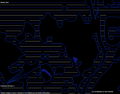

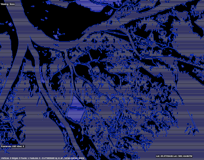
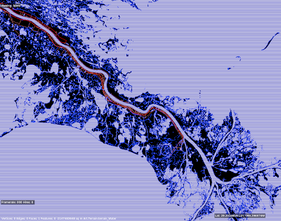
These are pictures of a test of the rasterizer. The rasterizer is code in both the DSF creator* and X-Plane that converts polygons into lines or boxes. What good is that? We use it to:
- Plant trees inside a polygonal forest in a DSF.
- Process all of the elevation points inside a polygonal water body when making a DSF.
Etc., etc. These were from a performance test rasterizing the Mississippi delta at 1201 x 1201; because the vector data is insanely detailed (something like 2 million line segments I think) it’s a good test of performance. The blue lines represent a line fit, but the white lines are a “box fit” – that is, they ensure that not only are they “inside” the water, but the area above and below them are too.
* Programming geeks can use this code – it’s in PolyRasterUtils.
This post is a bit of an experiment…we’ll see how it goes. When we cut the global scenery, we do a number of validations: we manually inspect some of the DSF tiles, we examine the Earth orbit textures (which are derived from the DSFs) as a quick way to look roughly at all of the tiles, we have a number of internal consistency checks in the generator, and we can compare our output to some of the input data (e.g. did we lose all of our water) to look for gross bugs. But we don’t have enough resources to manually examine all 18,000+ tiles in detail inside X-Plane.
So: if you have found a defect in a global scenery tile in version 9, please list the tile in the comments section of this post. I will try to give these “previously broken” tiles priority in manual inspection.
Note that the bugs we can expect in version 10 will be very different than in version 9 because we’ve really changed the global scenery generation process in nearly every important way. The underlying algorithms are heavily rewritten and data sources are very different. The goal here is to simply find areas that might have a higher probability of weirdness.
Let me try to be clear about what constitutes a broken tile and what does not. Please read this definition six or seven times before you post a comment.
- Do not report bugs of inaccurate data. If your favorite road is missing, or the coastline is in the wrong place, don’t report that here. That is not a defect in the rendering process; rather it is a limitation in the source data. I am not trying to collect a list of data inadequacies. We have already selected the new data for the new render. “Stuff is in the wrong place” is not a bug for this list!
- Really weird patterns are of interest. For example: I have seen some reports of very long thin bars of land going perfectly north along the edge of the tile, or a comb of mountain and valley, again perfectly vertical. These are bugs in the production process and I do want to know about them!
- Do not report errors in the placement of the 3-d layers (trees, roads, etc.). Since the 3-d layer is being completely rebuilt for version 10, none of these defects will be present in version 10. (They’ll be replaced with a totally new set of weird behaviors!)
- If an airport is too bumpy to use (with “flatten ” turned off in the sim), report this only if the terrain around the airport is grass. Basically the grass means that we tried to “fix” the airport in the v9 render and failed. If there is no grass (the airport is over forest or city) and it is bumpy, do not report it – that means it was added to apt.dat later.
- Do not report mismatches between the airport shape and the grassy patch; this is just the apt.dat file being updated.
If you have something to report (basically incorrect flattening of grassy airport areas and really weird coastline/terrain bugs that are clearly programming errors) please include three pieces of information:
- The DSF tile, e.g. +42-072
- The nearest ICAO of an airport near the bug (e.g. KBED)
- A very short description of what went wrong (e.g. “tall thin vertical lakes running through the entire DSF”).
Please only post defects of the above nature in the comments section of this blog post; to keep things clean I am going to nuke any off-topic comments on this post.
EDIT: see the first Squawk, Arista’s report on LOWS. This is a perfect report: it includes the DSF tile, the ICAOs, a brief but clear description, and it is a bug in how we process the data, not the data itself.


